 [1]
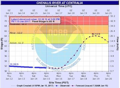
[1]Current and forecasted level of Chehalis River at Centralia as of 4:18 p.m. today. / Image from NWS Advanced Hydrologic Prediction Service [2]
By Sharyn L. Decker
Lewis County Sirens news reporter
CHEHALIS – Warmer weather, rising snow levels and a threat of heavy rain mean its time for those whose areas are prone to flooding to start monitoring the latests forecasts.
The National Weather Service says river flooding is possible this week across portions of Western Washington.
High temperatures could reach into the low 50s over the lowlands and snow levels would rise to above 6,000 feet by Tuesday, according to the weather service. Precipitation may begin late Monday and persist through at least Wednesday.
Windy conditions are possible in some areas beginning Monday night.
As of this afternoon, confidence is low as to the specific timing, magnitude and locations of the heavier rains, winds and potential flooding.
Rainfall totals of five to eight inches are possible in the Olympic Mountains during that 48-hour period, with four to seven inches possible in the Cascades, according to the NWS.
“Western Washington rivers are running low currently, but the rain will cause them to rise quickly and flooding could possibly begin Tuesday or Wednesday,” the NWS states.
People who reside in areas which traditionally flood ought to pay attention to the weather forecasts and keep an eye out for flood watches or flood warnings.
Flood watches have already been put into place in Cowlitz and Pacific counties.
Check the National Weather Service information for our area by checking the link called “Weather alerts, forecasts [3]” on the righthand sidebar, always here on LewisCountySirens.com [4]
Tip, for those who want to get a sense of how quickly the river level forecasts can change: Check your river level chart today and then check it again tomorrow, and the next day. “River levels [2]” from NWS, also always on the righthand sidebar of this page.